Exploring Cebu Province: A Comprehensive Guide to the Map and Its Treasures

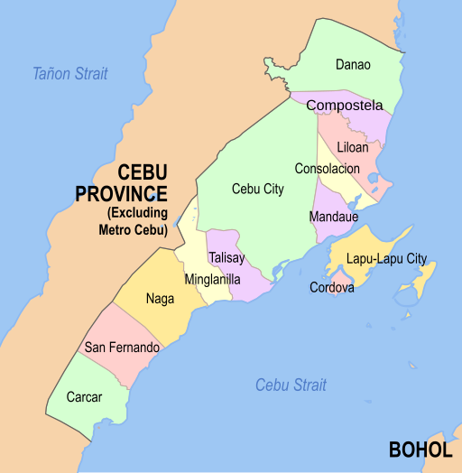
map of cebu province

Introduction to Cebu Province

Cebu Province, located in the Central Visayas region of the Philippines, is a prominent island destination known for its rich cultural heritage, historical landmarks, and economic significance. As the oldest city in the Philippines, Cebu City, the provincial capital, serves as a gateway to the province’s diverse attractions, which range from pristine beaches and diving spots to bustling urban centers and tranquil rural landscapes. Its strategic location in the heart of the Visayas has made Cebu a vital hub for commerce, trade, and tourism, earning it the moniker “Queen City of the South.”

Understanding the map of Cebu Province is crucial for both travelers and locals. With over 160 islets and islands, navigating the province’s geographical expanse can be daunting without a clear visual guide. The map of Cebu Province not only highlights key tourist destinations such as Mactan Island, Bantayan Island, and the Camotes Islands but also showcases the intricate network of roads, ports, and transportation systems that connect these points of interest. For travelers, a detailed map is indispensable for planning itineraries, identifying must-visit sites, and ensuring a seamless exploration of the region’s offerings.

For locals, the map of Cebu Province serves as an essential tool for understanding the spatial dynamics of their home. It aids in comprehending the distribution of resources, infrastructure, and services, which is vital for community planning and development. Additionally, the map’s detailed representation of Cebu’s topography, including its mountainous terrains and coastal areas, provides valuable insights into the province’s natural environment and potential areas for conservation and tourism development.

In essence, the map of Cebu Province is more than just a navigational aid; it is a gateway to discovering the cultural, historical, and natural treasures that make Cebu a unique and vibrant destination. Whether you are a first-time visitor or a long-time resident, delving into the map of Cebu Province unveils the myriad possibilities that await in this dynamic region.

Geographical Layout of Cebu

Cebu Province, located in the Central Visayas region of the Philippines, is composed of a main island and 167 surrounding smaller islands and islets. The main island, which forms the backbone of the province, stretches approximately 196 kilometers from north to south and is relatively narrow, with an average width of around 32 kilometers. This elongated shape provides a unique geographical layout that significantly influences the province’s climate and biodiversity.

The topography of Cebu is marked by a diverse array of landscapes. The central spine of the island is characterized by rugged mountain ranges, with the highest peak being Osmeña Peak, which stands at an elevation of 1,013 meters. These mountains are interspersed with valleys and rolling hills, creating a dynamic terrain that supports a variety of flora and fauna. The eastern and western coastal areas are primarily composed of narrow plains that taper off into sandy beaches and rocky shores, providing picturesque seascapes and fertile grounds for agriculture.

In addition to its mountainous regions and coastal plains, Cebu is home to several significant rivers and lakes. The largest river in the province is the Cebu River, which meanders through the central part of the island, providing essential water resources for both human consumption and irrigation. Other notable rivers include the Butuanon River and the Guadalupe River, each playing a vital role in the local ecosystem. There are also several smaller lakes and freshwater bodies scattered throughout the province that contribute to its rich natural heritage.

The surrounding smaller islands add to the geographical diversity of Cebu. Each island offers its own unique set of natural features, from coral reefs and white sandy beaches to lush mangrove forests and volcanic rock formations. This intricate network of islands and coastal areas makes Cebu Province a fascinating and complex region, well worth exploring through a detailed map of Cebu Province. The interplay between land and water creates a rich tapestry of environments that are both ecologically significant and visually stunning.

Major Cities and Municipalities

Cebu Province, an integral part of the Philippines, is renowned for its rich history, cultural heritage, and scenic landscapes. At the heart of this province lies Cebu City, the capital and the oldest city in the country. Known as the “Queen City of the South,” Cebu City is a bustling metropolis that blends historical landmarks with modern urban living. It features significant attractions such as the Magellan’s Cross, Basilica Minore del Santo Niño, and the vibrant Colon Street, the oldest street in the Philippines.

Adjacent to Cebu City, Mandaue is another key city that contributes to the province’s economic and industrial growth. It is home to numerous manufacturing companies and is known for its annual Mantawi Festival, which celebrates the city’s rich cultural heritage. The city’s strategic location and robust infrastructure make it a vital industrial hub in the region.

Further contributing to the province’s allure is Lapu-Lapu City, situated on Mactan Island. This city is famed for its beautiful resorts and historical significance. It is named after Lapu-Lapu, the native chieftain who defeated Portuguese explorer Ferdinand Magellan in the Battle of Mactan. The city offers a blend of history and leisure, with attractions such as the Lapu-Lapu Shrine and the pristine beaches that attract tourists from around the globe.

Talisay City, located to the south of Cebu City, is another notable urban center. Known for its historical relevance, Talisay was the site of the American landing during World War II. Today, it is a thriving city that boasts several historical sites, including the Liberation Park, and is known for its delicious lechon (roast pig), a local culinary delight.

Beyond these cities, Cebu Province is dotted with numerous municipalities each offering unique features and attractions. For instance, the municipality of Oslob is renowned for whale shark watching, while Moalboal is famous for its vibrant marine life and diving spots. Argao, with its Spanish-era architecture and delectable torta (a local pastry), also stands out as a must-visit destination.

Exploring the map of Cebu Province reveals a tapestry of diverse and vibrant communities, each contributing to the province’s charm and appeal. The blend of historical landmarks, cultural festivities, and natural beauty makes Cebu a compelling destination for both locals and tourists alike.

Historical Landmarks and Cultural Sites

Cebu Province, rich in history and culture, hosts several significant landmarks that offer a glimpse into the region’s storied past. One of the most iconic historical sites is Magellan’s Cross. Located in the heart of Cebu City, this cross symbolizes the arrival of Christianity in the Philippines, brought by the Portuguese explorer Ferdinand Magellan in 1521. The cross is housed in a small chapel near the Basilica Minore del Santo Niño, a location easily identifiable on any map of Cebu Province.

Adjacent to Magellan’s Cross, the Basilica Minore del Santo Niño stands as one of the oldest Roman Catholic churches in the country. Established in 1565, it is home to the revered statue of the Santo Niño de Cebu, a gift from Magellan to Queen Juana of Cebu. The basilica is a vital religious and cultural symbol, drawing countless devotees and tourists every year, thus marking its prominence on the map of Cebu Province.

Another historical gem is Fort San Pedro, the smallest and oldest triangular bastion fort in the Philippines. Constructed by the Spanish under the command of Miguel López de Legazpi, this fort was built to defend against pirate attacks and local revolts. Located at the Plaza Independencia in Cebu City, Fort San Pedro now serves as a museum, showcasing well-preserved artifacts from the Spanish era, providing a tangible connection to Cebu’s colonial past.

These landmarks are not only of historical importance but also serve as educational and cultural touchstones for both locals and visitors. The strategic locations of these historical sites are well-documented on the map of Cebu Province, making them accessible to all who wish to delve into the rich tapestry of Cebu’s history and culture.

Natural Attractions and Outdoor Activities

Cebu Province is renowned for its diverse array of natural attractions and outdoor activities that captivate both locals and tourists alike. The map of Cebu Province showcases numerous pristine beaches, majestic waterfalls, and challenging hiking trails, making it a haven for nature enthusiasts.

One of the most celebrated destinations is Kawasan Falls, located in the town of Badian. This multi-tiered waterfall, with its turquoise waters and lush surroundings, is perfect for swimming, canyoneering, and taking in the breathtaking scenery. Visitors can also trek through the jungle trails that lead to the falls, offering an immersive experience in Cebu’s rich natural environment.

Osmeña Peak, the highest point in Cebu, is another must-visit attraction. Situated in the municipality of Dalaguete, the peak provides panoramic views of the island’s rugged terrain and the surrounding ocean. Hiking to Osmeña Peak is a popular activity, with trails that cater to both novice and experienced hikers. The trek is relatively short but offers a rewarding experience with stunning vistas at the summit.

Malapascua Island, located in the northern part of Cebu, is a paradise for diving enthusiasts. Famous for its thresher shark sightings, Malapascua offers exceptional diving and snorkeling opportunities. The island’s coral gardens and marine biodiversity attract divers from around the globe. Apart from diving, visitors can explore the island’s serene beaches and engage in activities such as kayaking and paddleboarding.

Moreover, the map of Cebu Province highlights many other natural wonders, including the serene Bantayan Island, the enchanting Tumalog Falls, and the scenic Sirao Flower Farm. Each of these destinations presents unique opportunities for outdoor activities like biking, bird watching, and picnicking.

The natural attractions in Cebu Province are complemented by a variety of outdoor activities, ensuring that every visitor finds something to enjoy. Whether it’s diving in crystal-clear waters, hiking up rugged peaks, or simply relaxing on a tranquil beach, Cebu offers an unforgettable experience immersed in nature’s beauty.

Transportation and Accessibility

Cebu Province boasts a well-developed transportation infrastructure, making it accessible and navigable for both residents and visitors. A comprehensive map of Cebu Province reveals a network of major highways that facilitate seamless travel across the region. The primary artery is the Central Nautical Highway, connecting the northern and southern parts, while the Cebu South Road links the provincial capital, Cebu City, to the southern municipalities.

In addition to its extensive road network, Cebu is well-served by maritime routes. Ferry services operate regularly between Cebu City and neighboring islands, such as Bohol and Negros. The Cebu Port Authority manages the major seaports, ensuring efficient and safe maritime transport. For those looking to explore the smaller islands within Cebu Province, numerous local ferry services provide convenient and frequent connections.

Air travel is another vital component of Cebu’s transportation system. Mactan-Cebu International Airport, located on Mactan Island, is the main gateway for international and domestic flights. This airport is a hub for numerous airlines, offering direct flights to various destinations within the Philippines and across Asia. Additionally, smaller airports like Bantayan Island Airport and Camotes Island Airport cater to regional flights, further enhancing the province’s accessibility.

Navigating Cebu Province can be efficiently managed using both public and private transportation options. Public transport includes buses, jeepneys, and tricycles, which are widely available and offer affordable means of travel. For more comfortable and faster transit, taxis and ride-hailing services like Grab are readily accessible in urban areas. Renting a car provides flexibility and convenience, especially for those looking to explore the province at their own pace.

To maximize travel efficiency between key locations, it is advisable to plan routes in advance and consider peak travel times. Utilizing a map of Cebu Province can greatly aid in identifying the best routes and transport options. Understanding the schedules and routes of ferries and buses ensures a smooth journey, allowing travelers to fully appreciate the diverse and rich experiences Cebu has to offer.

Local Cuisine and Dining Destinations

Cebu Province offers a vibrant culinary scene that reflects its rich cultural heritage and diverse influences. One of the most iconic dishes is lechon, a whole roasted pig known for its crispy skin and tender meat. It is often considered the centerpiece of any grand celebration in Cebu. For an authentic experience, visitors can head to Carcar City, renowned for its exceptional lechon, or explore lechon stalls at Cebu City’s Carbon Market.

Another must-try is sutukil, a portmanteau of three cooking methods: sugba (grill), tuwa (stew), and kilaw (raw). This culinary trio offers a diverse taste of seafood, where fresh catches are prepared in various traditional ways. The Sutukil area near Mactan Shrine is a popular spot where diners can select their seafood and specify their preferred cooking method, ensuring a personalized dining experience.

Don’t miss out on puso, rice wrapped and boiled in woven coconut leaves, which serves as the perfect companion to many Cebuano dishes. This portable and eco-friendly rice package is often paired with grilled meats and seafood, making it a staple in local eateries and street food stalls.

For those looking to explore more of Cebu’s culinary landscape, there are several dining destinations and markets to consider. Larsian BBQ, located along Fuente Osmeña Circle, is a bustling haven for barbecue enthusiasts. Here, visitors can indulge in a variety of grilled meats and seafood, best enjoyed with puso and dipping sauces.

Tops Lookout in Busay offers not only panoramic views of Cebu City but also a range of dining options. The restaurants here provide an opportunity to savor Cebuano dishes while taking in the scenic vistas. Meanwhile, Taboan Public Market is the go-to place for dried fish and other local delicacies, providing a glimpse into the province’s vibrant market culture.

For a comprehensive experience, visitors can refer to the map of Cebu Province to locate these culinary hotspots and plan their gastronomic journey accordingly. This map serves as a guide to the key food destinations, ensuring that travelers don’t miss out on the best that Cebu has to offer.

Tips for Travelers and Final Thoughts

When planning a trip to Cebu Province, utilizing a detailed map of Cebu Province can greatly enhance your travel experience. This map will not only help you navigate through the diverse landscapes but also allow you to pinpoint must-see destinations efficiently.

First and foremost, safety should always be a priority. While Cebu Province is generally safe for tourists, it’s crucial to stay vigilant, especially in crowded areas. Keep your belongings secure and avoid carrying large amounts of cash. Additionally, it’s wise to research local emergency contact numbers and the location of the nearest hospitals and police stations.

The best time to visit Cebu Province is during the dry season, which typically lasts from December to May. During these months, you can enjoy pleasant weather and participate in various outdoor activities without the interruption of rain. However, be mindful that this is also the peak tourist season, so booking accommodations and attractions in advance is advisable.

Understanding and respecting local cultural etiquette is essential when visiting Cebu. Filipinos are known for their hospitality, and it’s important to reciprocate this by being courteous and polite. Dress modestly, especially when visiting religious sites, and always ask for permission before taking photographs of people or private properties.

Throughout this guide, we have delved into the various attractions and hidden gems found in Cebu Province. From pristine beaches to historical landmarks, the region offers a plethora of experiences for every type of traveler. Utilizing a map of Cebu Province will not only help you plan your itinerary but also ensure you don’t miss out on any significant sites.

In conclusion, Cebu Province is a treasure trove of natural beauty, rich history, and vibrant culture. By following these tips and relying on a well-detailed map, you can make the most of your trip and create unforgettable memories. Safe travels!

Scroll to Top